South America etiketine sahip kayıtlar gösteriliyor. Tüm kayıtları göster

28 Mayıs 2016 Cumartesi

Bolas used by ancient Inca

Bolas used by ancient Inca

Residing in a mountainous terrain that yielded little wood, the Inca’s most effective weapons were stones, rolled down hills or hurled from slingshots. Stones thrown from slings were the common weapon that could be used from a distance.

Inc also threw bolas. Bolas is a type of throwing weapon made of weights on the ends of interconnected cords, which hurled at the legs of enemies to bring them to their enemies.

Bolas were most famously used by the gauchos or Argentinean cowboys but that have been found in excavations of Pre-Columbia settlements, especially in Patagonia, whore indigenous peoples used them to catch 200-pound guanaco (Ilamalike mammals) and nandu (birds).

They were also used in battle by the Mapuche and Inca army. Bolas were used extensively against the Spanish, especially to cripple their horses. When the bolas were spun around, then hurled, the stones encircled that arms or legs of an enemy.
Bolas used by ancient Inca 

2 Mart 2012 Cuma

Maya Classic Period

Maya Classic Period

Maya Classic Period
Maya Classic Period

During the Classic Period, which is divided into Early (250–600 c.e.), Late (600–800), and Terminal (800–900/1100), Maya civilization reached the pinnacle of its cultural, economic, and political development.

From the 200s to the 400s c.e. dozens of autonomous city-states, many founded in the Preclassic, others early in the Classic, jockeyed for power. By the 500s two had gained preeminence: Tikal and Calakmul.

These were sprawling city-states of 100,000 people or more, with towering pyramids and temples, massive civic and ceremonial centers, outer rings of lesser compounds and residences, and intensively farmed hinterlands extending many miles. A hereditary king and a small class of elites controlled vital trade routes and secondary centers and aggressively pursued conquest of and alliances with other polities.


From the 500s to the 700s a series of highly destructive wars erupted between these two great powers and their respective allies. Elsewhere in the Maya zone other city-states engaged in the same process of expansion, alliance building, and warfare.

Then, for reasons still much debated, in the 700s and 800s all of these polities underwent steep declines, with more than a dozen major and scores of lesser urban complexes abandoned by the early 900s. A resurgence in northern Yucatán, beginning in the 800s and marked especially by the rise of Chichén Itzá, also declined by the late 1000s.

This 600- to 800-year period saw the flourishing of commerce, architecture, engineering, writing, mathematics, calendrics, astronomy, cosmology, and artistic creations of every description across the Maya zone, achievements that emerged together as part of a broader process of cultural, economic, and political development.

Mayan writing

While the origins of Mayan writing in the Middle Preclassic remain obscure, by the Late Classic the Maya had developed the most sophisticated writing system in the history of the pre-Columbian Americas, one of only a handful of independently invented writing systems in the history of the world.

After more than a century of painstaking effort by scholars on several continents, breakthroughs in the 1970s and 1980s permitted many of these ancient texts to be read for the first time.

By the Early Classic anything that could be spoken in Maya could be rendered as written text. Using a script consisting of more than 800 glyphs in a characteristic round or oval shape and intricate style, Mayan writing employed both logographs and phonetic signs.

Read from top to bottom and left to right, these glyphs are classified as "main signs” and "affixes", with the latter made up of prefixes, suffixes, superfixes, subfixes, postfixes, and infixes.

Such written texts, often accompanied by dates and graphic depictions of human figures and divine entities (stylistically not altogether unlike contemporary graphic novels), appear on carved monuments, murals, pottery, other artifacts, and a handful of surviving folded-paper codices.

The Spanish destroyed hundreds and perhaps thousands of these codices during the conquest, a purposeful eradication of vast quantities of accumulated knowledge on par with the burning of the library of Alexandria.

Most extant texts memorialized significant episodes in the lives of kings, though many recorded wars, dynastic alliances, and other major events. (Many personal items conveyed more prosaic information, such as "his cup" or "his bowl").

If only a tiny fraction of the populace could write or read, the prominent display of these texts in civic and ceremonial spaces on imposing and magnificently carved stone stele, stairways, altars, lintels, and other public monuments were clearly intended to convey unequivocal messages of the king’s divine power to all who bore witness to them.

Maya Innovations

Intimately linked to writing and no less remarkable for their sophistication were Maya mathematics and calendrics. Having invented the mathematical concept of zero—evidently making them the world’s first civilization to do so—the Maya went on to undertake fantastically complex mathematical calculations.

Their numerical system was vigesimal (based on the number 20), most commonly written using a bar-and-dot notation, with a dot representing one; a bar, five; and a shell-like figure, zero. With these simple notations they were able to calculate numbers into the millions and accurately predict lunar and solar eclipses thousands of years into the future.

The Maya conceived of time as a series of recurring cycles. All Mesoamerican peoples shared three cyclical calendars: the 365-day solar year, the 260-day sacred almanac, and the 52-year "calendar round". These three calendars, which can be visualized as three interlocking wheeled gears, made each of the 18,980 days of the 52-year "calendar round" unique.

The Maya added to this what scholars call the "Long Count" or "Initial Series", which was independent of the other cycles and served as an absolute chronology by tracking time from a fixed or "zero" date far in the past. Evidently they were the first world civilization to mark time from a fixed date.

According to the Long Count, the world came to an end and was created anew every 5,128 solar years, at the close of each "great cycle". The current world, by this calendar, will end on December 21, 2012.

Like all Mesoamerican civilizations, the Maya invested the movements of the Moon, Sun, planets, and stars with deep religious and cosmological significance, often designing and constructing their temples, shrines, and other edifices to align with astronomical observations.

These celestial bodies represented gods and deities, and there is no evidence that the Maya understood the circular or elliptical orbits of the Moon, Earth, and planets as discovered by Copernicus and Kepler centuries later.

Maya religion and cosmology were exceedingly complex, an all-encompassing system of belief in which the distinction between sacred and secular did not exist. Rivers, rocks, caves, springs, and other natural features were seen to possess divine powers, while a multiplicity of spirits and deities, including ancestor spirits, infused every aspect of everyday life.

Creation myths emphasized the cyclical re-creation of the world by dualistic divine beings who entered Xibalbá, or the Otherworld, "a place beyond death inhabited by ancestors, spirits, and gods—the place between the worlds", according to Friedel et al., outwitted the gods, and became divine kings.

The most elaborate Maya treatment of creation myths and cosmology is the Popol Vuh, a uniquely revealing book written by the highland K'iche (Quiché) Maya after the Spanish conquest.

Economy, Society, and Politics

The economic foundations of Classic Maya city-states and kingdoms consisted of extensive and intensive agriculture supplemented by hunting, fishing, and gathering; craft specialization; and local, regional, and longdistance trade, all of dizzying complexity.

Society was divided into two broad groups: a tiny group of elites and the great majority of commoners, with fine gradations in status at all levels. In some instances a more prosperous strata of commoners emerged, though on the whole wealth and power were highly centralized and concentrated in very few hands.

Political power was exercised by hereditary ruling dynasties. At the pinnacle stood the king ("sacred lord", or k'uhul ajaw), almost always male and considered a divine or semidivine being. Beneath him was a small group of high-ranking elites—warriors, high priests, scribes, and administrators.

Interstate politics were byzantine, with alliances between polities generally consummated through dynastic marriages. Kingdoms were formed by conquest and domination of lesser polities, whose ruling houses the conquering power generally left intact.

The decline of the massive city-state of El Mirador in the late 100s c.e. created a power vacuum in the lowlands that was soon filled by other emergent polities, most notably Tikal and Calakmul. From the 100s to the late 300s, when it allied with mighty Teotihuacan, Tikal became the preeminent Maya kingdom, its power stretching from the northern lowlands as far south as Copán in Honduras.

In the 400s Calakmul began to challenge Tikal through conquests and alliances intended to encircle and weaken its adversary. In 562 Calakmul defeated and sacked Tikal. There followed a period of intense conflict lasting more than a century.

"The giant war went back and forth", in the words of Arthur Demarest, until 695, when Tikal "roared back and crushed Calakmul. And then the Maya world just broke up into regional powers, setting the stage for a period of intensive, petty warfare that finally led to the collapse of the Maya".

During the Late Classic, similar processes unfolded to the southwest among the kingdoms of the Usumacinta River, most notably in the centuries-long conflict between Piedras Negras and Yaxchilán.

The war between these two regional powers and their allies raged off and on from the 400s to the 800s, finally ending in the defeat of Piedras Negras in 808. Another major regional conflict between Copán and Quiriguá, far to the south along the contemporary Guatemala-Honduras border, had a similar denouement.

By the 800s, as the kingdoms of the southern and central lowlands declined, the northern lowlands saw numerous polities rise to prominence in the 900s and 1000s, particularly in the Puuc region of western Yucatán. To the east the kingdom of Chichén Itzá, founded in the late 700s, soon became the most powerful and populous state in all of Maya history.

With a more decentralized political structure and diversified economic base than its weakening southern neighbors, Chichén Itzá prospered from the 800s through the 1000s, when it too experienced a period of decline and was all but abandoned by 1100.

Causes for Decline

A complex combination of factors most likely caused the decline of Classic Maya polities. Despite much variability in time and place, the most plausible scenarios point to the interplay of overpopulation, long-term ecological crises, endemic warfare, and the erosion of the moral legitimacy of divine kings in the eyes of the populace.

By the 800s the Maya lowlands were inhabited by tens of millions of people, probably exceeding the carrying capacity of the land even under optimal conditions.

Over time, surging population densities and ever more intensive and extensive agriculture and urban construction led to widespread deforestation, worsening soil erosion, and declining soil fertility, in some cases exacerbated by prolonged drought. The evidence shows that these processes caused increasing incidences of malnutrition and disease and fundamental ecological bottlenecks that in the end proved insoluble.

Endemic warfare was both symptom and cause of these deleterious processes. By the early 500s warfare was consuming prodigious quantities of material and human resources, and by the late 700s the cycles of violence had begun spinning out of control, with a series of ever more destructive wars overtaxing not only the land and the people but, no less important, commoners' faith in the moral legitimacy of their kings.

Since Maya kings ruled by virtue of divine sanction, any prolonged crisis—economic, ecological, political—could set in motion a profound spiritual-religious-moral crisis among the general populace, whose labor and faith were necessary to keep the whole system operating.

All of these factors, working in dynamic and contingent combination, were most likely responsible for the decline of one of the world's most creative, original, and sophisticated civilizations.

1 Mart 2012 Perşembe

Maya Preclassic Period

Maya Preclassic Period

Maya Preclassic Period

During the Early Preclassic (2000–1000 b.c.e.) the two major archaeological markers of civilization in the Maya zone first emerged in the Pacific and Caribbean coastal regions: permanently settled agricultural and/or maritime villages and pottery.

The earliest known examples of Mesoamerican pottery have been found along the Pacific coast from Chiapas, in Mexico, south and east to El Salvador.

Scholars subdivide these ceramic styles into three phases: Barra (c. 1850–1650 b.c.e.), which apparently emerged from an earlier tradition of gourd containers; the more sophisticated Locona (c. 1650–1500 b.c.e.); and the more elaborate and diverse Ocos (c. 1500–1200 b.c.e.).


Handcrafted clay-fired figurines, many with highly individualized styles and motifs, also proliferated during this period. A wide variety of other goods made from perishable materials, including textiles, baskets, and nets, were also likely common, though they have left few traces in the archaeological record.

The origins of complex society in the Maya zone have been traced to the Pacific coast Locona phase. Evidence includes differential house sizes, part-time craft specialization, and funerary practices.

Excavations at Paso de la Amada, Chiapas, have unearthed one house considerably larger than others at the site, and renovated at least nine times, suggesting both growing social differentiation and high spiritual and aesthetic value placed on continuity of place and homage to ancestors.

The superimposition of dwellings and other buildings around a previously sanctified place is characteristic of Maya (and Mesoamerican) construction practices generally.

A nearby site has revealed a burial of a small child adorned with a mica mirror, indicating the growing importance of hereditary inequality. Further east along the coast of contemporary Belize, the Early Preclassic saw the growth of numerous maritime settlements, founded during the late Archaic (c.3000 b.c.e.) that by the Middle Preclassic had expanded west into the interior.

Similar developments may have been taking place in the highlands as well, though subsequent volcanic activity likely buried these settlements, rendering them inaccessible and thus creating an evidentiary bias in the archaeological record.

Other important Early Preclassic sites have been excavated in Honduras (Copán Valley, Cuyamel Cave, Puerto Escondido) and El Salvador (Chalchuapa). The inhabitants of these and other Early Preclassic settlements made their living through a combination of swidden agriculture, fishing, hunting, and gathering.

Bone isotope analyses show that maize constituted less than 30 percent of their diet, far less than the average for many contemporary Maya, which approaches 75 percent. Extant pottery from this period indicates the emergence and spread of a shared corpus of religious symbols, beliefs, and concepts that formed the basis for later cultural developments.

Middle Preclassic

The Middle Preclassic (1000–400 b.c.e.) witnessed growing social complexity among coastal and piedmont communities and the expansion of complex societies into the highlands and, to a lesser extent, the lowlands. Social differentiation intensified, as symbols of status and power came increasingly under the control of a small group of rulers and elites.

Prestige items such as mirrors, masks, ear spools, blood letters, and specialized vessels often made or adorned with precious minerals or stones (jade, obsidian, pyrite, and others) became increasingly common and elaborate.

A shared body of religious beliefs, ritualized and controlled by a small class of ruler-priests, served as the ideological underpinnings of an increasingly unequal society. Public works also grew in size and complexity, indicating a growing degree of elite control over surplus labor.

One of the largest of the Middle Preclassic sites is La Blanca along the Río Naranjo on the Pacific coastal plain in contemporary Guatemala. Mostly destroyed by modern development, the site covered 99 acres and included at least 40 smaller houses and four large earthen mounds covering the ruins of temples or other public works.

The largest of these latter measured 182,987 sq. feet at its base and rose more than 82 feet high, making it one of the largest structures in Mesoamerica at the time.

The polity, which flourished from 900 to 650 b.c.e. and was abandoned 50 years later, ruled an estimated 60 settlements in an area of perhaps 127 sq. miles administered through at least two secondary centers.

These patterns of growth and collapse, mounting social differentiation, and multitiered administrative hierarchy typified the later rise, expansion, and decline of scores of city-states across the Maya region.

Other important Pacific coast Middle Preclassic sites include El Mesak and El Ujuxte, both of which, along with La Blanca, show close economic and cultural contact with the Olmec civilization far to the north along the Gulf of Mexico littoral.

In the highlands the city of Kaminaljuyú (place of the ancient ones) grew to become the largest highland Preclassic Maya capital. Founded in the Early Preclassic and eventually covering some 2 sq. miles, the city extended its reach to dominate numerous satellite settlements by around 500 b.c.e., waxing and waning in power until its final collapse toward the end of the Classic—some 2,000 years after its founding.

Already by the Middle Preclassic there is evidence for extensive earthworks, canals, temples, and other public works, along with a carved monument depicting a succession of rulers seated on thrones receiving homage from bound and kneeling captives.

Other highland Middle Preclassic centers include El Portón and the adjacent burial site of Las Mangales, which provides clear evidence of warfare, tribute, and sacrifice of war captives.

This growing public expenditure of labor, social differentiation, and militarism along the coast and in the highlands during the Middle Preclassic contrast with the simpler constructions and relative egalitarianism found in the lowlands to the north.

Still, the overall trajectories are very similar, with the lowlands having been settled later. The most intensively studied lowland centers in the Middle Preclassic include Altar de Sacrificios and Nakbé in Guatemala, and Blackman Eddy, Cuello, K’axob, and Cahal Pech in Belize.

In particular, the El Mirador Basin at the northernmost tip of the contemporary Guatemalan Petén (where the Nakbé ruins are located) saw the rapid development of numerous major urban centers, including El Mirador, Wakna, and Tintal.

Also during the Middle Preclassic, the inhabitants at more than 20 sites in the lowlands of northwestern Yucatán built sizable urban centers with characteristic Maya ball courts and temple complexes.

The Middle Preclassic, in short, was a period of rapid transformation and growth across much of the Maya zone. Large urban centers with accompanying monumental architecture—including temples, plazas, palaces, ball courts, causeways, and elaborately carved monuments—sprang up over the course of just two or three centuries, dotting much of the landscape by the end of the period.

This rapid growth suggests a high degree of centralized control over surplus labor, as well as deepening institutionalization of inherited inequalities, though to date no tombs of lowland Middle Preclassic rulers have been uncovered. Just as significant, the evidence also shows many signs of trade and exchange and of intensifying competition, conflict, and warfare between these emergent polities.

Late Preclassic

The Late Preclassic (400 b.c.e.–100 c.e.) saw the emergence of what is conventionally termed civilization across the Maya zone. The period as a whole was characterized by surging populations, deepening social stratification, increasing centralization of political power, expanding public works, heightening militarism and warfare, and, especially significant, the full development of writing and calendrics.

The origins of Mayan writing during the Middle Preclassic remain obscure, with evidence of both Isthmian influence from the Veracruz region to the north and of independent invention.

But whatever its specific origins, Mayan writing reached full flower during the Late Preclassic, as did the practice of dating events from a fixed point in time in the past, the so-called Long Count. Surviving artifacts with Long Count dates permit scholars to determine chronologies and sequences of events with considerable accuracy.

The largest and most important polity in the southern Maya zone in the Late Preclassic was Kaminaljuyú. Control of quarries with valued minerals combined with control over vital trade routes—both north to south and east to west—permitted the city’s rulers to consolidate their power over an area of hundreds of sq. miles.

Sadly, because this site lies adjacent to contemporary Guatemala City, most of it has been destroyed by commercial and residential development. Other important Late Preclassic sites in the south include El Ujuxte, Tak’alik Ab’aj, Chocola, Chalchuapa, and El Guayabal in the Copán Valley in contemporary Honduras.

In the lowlands to the north the largest polity of this period was El Mirador, which, like Kaminaljuyú, was the center of an expansive regional trade and political network.

With a massive triadic pyramid at its western edge (a structure dubbed El Tigre), and its ceremonial and civic core extending about a mile to the east—a core that included temples, palaces, ball courts, tombs, and vaulted masonry buildings—El Mirador rivaled in size and complexity the largest Classic Period urban centers, including Tikal and Palenque. Some scholars consider El Mirador the earliest preindustrial state (as opposed to chieftaincy) to emerge in the Maya lowlands.

Other important Late Preclassic lowland sites include Cerros, Nohmul, Lamanai, Tikal, Uaxactún, and San Bartolo (the latter, not discovered by archaeologists until 2001, contained some of the most magnificent Maya murals ever uncovered, pushing the date of the full flowering of Maya art back centuries, to at least 100 b.c.e.).

For reasons that remain murky these and other Late Preclassic centers underwent a period of precipitous decline during the Terminal Preclassic (100–250 c.e.). Some have pointed to the catastrophic eruption of Ilopango volcano (near contemporary San Salvador), which covered thousands of sq. miles in ash and rendered the entire area within a 62-mile radius uninhabitable for at least a century, as partly responsible. Others have suggested that shifts in migratory patterns, disruptions in trade routes, ecological bottlenecks, dynastic crises, and other factors also played a role.

Whatever the exact causes, it is clear that many important Maya polities experienced dramatic declines during the Terminal Preclassic, setting the stage for the extraordinary cultural, economic, and political renaissance of the Classic Period.
Mesoamerica Archaic and  Preclassic Periods

Mesoamerica Archaic and Preclassic Periods

The geographical region and culture zone called Mesoamerica (literally, "Middle America") extends from present-day central and southern Mexico as far south as northern Nicaragua (approximately 21 to 13 degrees north latitude).

The Archaic Period (8000–2000 b.c.e.) in this vast and variegated region was characterized by the first emergence of settled communities and agriculture. The Preclassic Period is conventionally subdivided into Early (2000–1000 b.c.e.), Middle (1000–400 b.c.e.), Late (400 b.c.e.–100 c.e.), and Terminal Preclassic (100–250 c.e.).

Economic, political, and cultural developments in each of these periods are marked by both broad similarities and regional variations—periods most fruitfully seen as convenient dating devices rather than fixed horizons characterized by definitive shifts.

Four major Mesoamerican cultural complexes emerged during the Preclassic: the Olmecs along the Gulf of Mexico littoral, in the Valley of Oaxaca, in the Valley of Mexico, and further east and south in the Maya zone.


Archaic Period

In the early Archaic Period people in various parts of Mesoamerica initiated a shift from nomadic hunting and gathering to more territorially based specialized foraging, a prolonged process culminating in sedentary agriculture.

The first permanent villages appeared along the Gulf of Mexico, Caribbean, and Pacific seacoasts early in the Archaic, likely a result of the relative abundance of maritime food resources in these areas.

Sites demonstrating year-round occupation during the Archaic include Cerro de las Conchas on the Chiapas coast, several along the Caribbean coast in contemporary Belize, and inland along rivers at Colha and Cobweb Swamp.

While the precise origins of Mesoamerican agriculture remain obscure, scholars agree that over many generations people in two principal regions domesticated several species of wild plants during the Archaic that later served as the agricultural basis of Preclassic and Classic Mesoamerican civilizations, most notably maize, squash, beans, and chili peppers, usually grown together in a milpa.

These regions were the highlands of Oaxaca and Tehuacán (southeast of the Valley of Mexico) and the coastal lowlands of the Gulf of Mexico and Pacific. The origin of maize in particular has spawned extensive debates and a voluminous literature.

The resulting food surpluses resulted in higher populations and the beginnings of more complex societies marked by growing social differentiation, craft specialization, and localized trade—especially food, flint, obsidian, chert, textiles, and feathers.

Early Preclassic

The Early Preclassic was marked by denser populations, the expansion and increasing complexity of settled communities, specialized craft production—pottery and stylized figurines being the most evident in the archaeological record—more extensive regional trading networks, more marked social differentiation, and the beginnings of warfare.

The earliest evidence for sustained Mesoamerican warfare, from the Zapotec in the Valley of Oaxaca, dates to around 1800 b.c.e. Armed conflicts in this zone intensified thereafter, culminating in the supremacy of the Monte Albán polity over the entire Oaxaca watershed by the end of the Preclassic.

The earliest Mesoamerican pottery has been traced to the Pacific coast of Chiapas and areas further south, extending as far as contemporary El Salvador. Evidence for increased social differentiation during the Early Preclassic includes differences in house sizes, attainment of status goods, and funerary practices.

This period also saw the rise of the Olmec, long considered the "mother culture" of subsequent Mesoamerican states and polities, a view that in recent years has been displaced by a more multiregional perspective.

Middle Preclassic

During the Middle Preclassic these complex societies developed further along the trajectory established during the earlier period, with more centralized and hierarchical polities emerging in the Valley of Oaxaca, Chalcatzingo, the Valley of Mexico, and the Maya lowlands and highlands.

Some areas saw the transition from chiefdoms to states, most notably in Monte Albán I (c. 500–200 b.c.e.) in the Valley of Oaxaca. The period also saw the consolidation of hereditary rule and the origins of notions of divine kingship.

As populations and population densities grew, social differentiation became more pronounced, with finer distinctions among members of the elite and a wider gap between elites and commoners. Ruling and religious elites deployed spiritual power to underpin their legitimacy and rule.

This period saw the crystallization of a pan-Mesoamerican culture zone, with widespread and continuous exchange of goods and ideas across the region. Exchanges of prestige goods such as magnetite, jade, pyrite, pearl oyster shells, and quetzal feathers accompanied exchanges of religious beliefs and symbols.

This period also saw growing sophistication in the development of monumental architecture and carved monuments. The first carved monuments in the Valley of Oaxaca date to 1000 b.c.e. Here, at Monte Albán, a rudimentary system of glyphs had developed by 500 b.c.e.

During Monte Albán I rulers erected more than 300 carved monuments recording names, dates, and events, many with martial themes and motifs, including ritual sacrifice of captive war victims. Scholars have yet fully to decipher these glyphs.

Similar developments took place among the Maya, with elaborately carved stelae serving as public displays of rulers’ authority, power, and legitimacy. Middle Preclassic Maya monuments were erected from Chiapas as far east and south as El Salvador.

Across Mesoamerica, as contending polities jostled for power, warfare grew in scale and complexity. Agriculture became more intensive, evidenced by denser populations and more elaborate water-control technologies. Pottery styles, too, became more elaborate, sophisticated, stylized, and varied.

Late and Terminal Preclassic

The Late Preclassic, characterized by a veritable "urban revolution", laid the groundwork for the florescence of states and polities during the Classic Period. In Mexico’s central highlands planners designed, laid out, and began construction of the colossal city of Teotihuacán, which came to dominate much of Mesoamerica during the Early Classic Period.

Further south Monte Albán II (c. 250 b.c.e.–1 c.e.) was expanded as a residential and ceremonial center, as its ruling elite consolidated its control over the region.

In the north and west (in contemporary Nayarit, Jalisco, and Colima), urbanization, state building, and attendant monumental architecture were of a lesser scale, with pottery and artistic styles, along with funerary practices, exhibiting distinctive regional variations.

In the east, along the Gulf Coast the Olmec center of Tres Zapotes continued to thrive, while the adjacent urban centers of La Venta and San Lorenzo waned in influence and power.

The most stunning achievements of the Late Preclassic took place among the Maya, where advances in writing, mathematics, astronomy, architecture, urban planning, warfare, and related spheres presaged the later developments of the Classic Period.
Mesoamerica Classic Period

Mesoamerica Classic Period

Mesoamerica Classic Period

The Classic Period in Mesoamerican history is divided into the Early (250–600 c.e.), Late (600–800), and Terminal Classic (800–900/1100). Four major culture areas reached florescence during this period: the central highlands, dominated by Teotihuacán until its fall in 650.

The Oaxaca Valley, dominated by Monte Albán until its fall around 900; along the gulf coast among the Classic Veracruz, which reached its apogee around 900; and four distinct Maya zones, most of whose city-states collapsed by the late 800s.

The overall trajectory of this period was characterized by incremental and continuous social and cultural development, economic expansion, and state formation in all four culture areas, growing organically out of Preclassic developments, followed (except in the case of Classic Veracruz) by the sudden and calamitous collapses of states and empires marking the end of the Classic —demises whose underlying causes remain a subject of research and debate among scholars.


The Central Highlands and Teotihuacan

Called the "City of the Gods" by the Aztec centuries after its abandonment, the colossal city of Teotihuacán remains shrouded in mystery. Its inhabitants left many monuments, carvings, murals, and other artistic creations, but only a few glyphs and no readable texts comparable to the writings of the Maya. We do not even know what they called themselves.

What is clear is that the city’s ruling elite oversaw a city of some 150,000 – 200,000 people—making it one of the largest urban concentrations in the world at that time—and an empire that spanned most of Mesoamerica outside the Oaxaca Valley and the Maya zones to the south and east.

For centuries the dominant power in the Valley of Mexico, the empire of Teotihuacán extended its economic and ideological reach north as far as the present-day U.S. Southwest, west to the Pacific coast, east to the Gulf of Mexico, and south as far as Honduras.

Teotihuacán’s influence in Mesoamerica was of three principal types: political-military, economic, and ideological-religious. Politically and militarily the city directly ruled most of the central highlands, including the densely populated Valley of Mexico, which saw its population increase by a factor of 40 in the 10 centuries from 900 b.c.e. to 100 c.e.

In towns and districts directly ruled by the empire’s armies, labor drafts and exacted tribute were combined with the construction (or reconstruction) of new towns and urban centers in styles imitative of the colossal city. Economically the empire established and maintained extensive trade and exchange networks throughout Mesoamerica.

Teotihuacán-style merchant residences show this as far south as Guatemala and by a wide variety of identifiable exchange items spread over a large area (such as green-tinted obsidian unearthed at sites in Honduras from the Teotihuacán-controlled Pachuca quarry).

It was in the ideological or spiritual realm that the city-empire exercised its greatest power. In particular, its cult of Quetzalcoatl (the Feathered Serpent), already a pan-Mesoamerican deity, became increasingly important throughout much of Mesoamerica. So too did its practice of ritual human sacrifice, probably derived from the Olmecs, Maya, Monte Albán, or other antecedent cultures.

The dispersal of these and other religious myths, symbols, and practices from Teotihuacán to the central highlands and beyond, as well as the persistence of these myths and practices in the centuries following the city’s demise, demonstrate the tremendous ideological influence wielded by the empire and its ruling elite.


The Classic Veracruz

What caused Teotihuacán’s fall is unknown, though a combination of ecological crises and invasions from the north are the likeliest reasons. What is known is that around 650 c.e. parts of the city were burned and desecrated and most of the city itself abandoned.

The resultant power vacuum in the central highlands led to the formation of numerous lesser states, most notably Cholula and Cacaxtla in contemporary Puebla, and Xochicalco in Morelos. Along the Gulf of Mexico coastal region, the Classic Veracruz, most commonly associated with the urban complex of El Tajín, emerged as perhaps the most powerful polity north of the Maya zones.

Noted especially for its many ball courts—the ball game, or ollama, comprising another pan-Mesoamerican cultural tradition closely associated with warfare and ritual human sacrifice and steeped in religious symbolism—El Tajín reached its florescence around 900 c.e. All of these states exhibited a heightened emphasis on militarism that would characterize the later Postclassic Period.

The Oaxaca Valley and Monte Alban

In the Valley of Oaxaca the highly militarized Zapotec state of Monte Albán came to dominate the surrounding region through conquest, colonization, and alliances with lesser powers. During the period of Teotihuacán’s dominance Monte Albán and Teotihuacán enjoyed good diplomatic relations, evidenced in part by carved monuments at Monte Albán depicting ambassadorial meetings and by neighborhoods within Teotihuacán that housed Zapotec merchants.

In Monte Albán, too, a hereditary class of kings and priests whose legitimacy was divinely sanctioned dominated a rigidly hierarchical social order held together by war, threats of war, and an elaborate corpus of religious beliefs and practices, including ritual sacrifice of captive war victims.

Monte Albán reached the zenith of its power around 400 c.e., after which numerous of its vassal towns and districts wrested their autonomy from the hilltop city, which subsequently underwent a period of gradual decline. By 800 parts of the city were no longer inhabited or used, though the site and surrounding districts were occupied well into the Postclassic.

The Maya

The most remarkable cultural achievements of the Classic Period took place among the Maya. In virtually every field of human endeavor—writing, mathematics, astronomy, calendrics, warfare, architecture, agriculture, water-control technologies, and many others — the Classic Maya bequeathed an astounding legacy.

Comprised of a shifting mosaic of city-states that never unified under a single political umbrella, the history of the Classic Maya is conventionally divided into the Early (250–600 c.e.) and Late Classic (600–900), with a political reorganization in Yucatán, originating largely from outside the region and enduring until around 1100.

Scholars also divide the Maya area into four principal geographic zones:
  1. The Pacific coastal plain and piedmont, which merge into 
  2. The northern highlands in contemporary Guatemala and Chiapas, which merge into 
  3. The southern and central lowlands, or Petén, and further north into 
  4. The northern or Yucatán lowlands.

While economic, social, cultural, and political developments in each of these zones followed distinct trajectories, it is also the case that Classic Period developments in the Maya region as a whole exhibited a range of shared features and attributes that need to be understood within both pan-Maya and pan-Mesoamerican contexts.

29 Şubat 2012 Çarşamba

Migration Patterns of The Americas

Migration Patterns of The Americas

Migration Patterns of The Americas
Migration Patterns of The Americasn

Native Americans inhabited every region of the Western Hemisphere, from arctic North America to Tierra del Fuego at the southern tip of South America. There are more than 500 distinct Native American tribal groups or nations in North America alone. Native people showed a remarkable ability to adapt to the different physical environments throughout North America.

They organized themselves into communities, governments, and cultures that were adapted to their local environment and were recognized as distinct tribes or nations by the people within the tribe as well as by the other Native nations. Native Americans’ own stories of how they arrived in their homelands are as varied as the tribes themselves.

There are some common themes, however, to these creation stories and oral traditions. All tribes have a creation story; most tell of humans being brought up from the ground by spiritual powers, and each culture tells of its own tribe as being the original people. This is usually a positive story, with humans being brought into this world with joy, companionship, and laughter.


Native cultures have a strong sense of distinct male and female powers and principles in the universe, and often these creation stories tell of the male spirits of the sky and Sun bringing humanity up from the female counterpart, the womb of Mother Earth. Sometimes these stories tell of the women pushing the men to venture out of the earth (or up from a lake or to embark on a long journey) to find the new world in the light.

Some tribes’ creation stories tell of their people emerging from the earth directly into their homeland. But many of them tell of a long migration: The people emerge and travel a great distance to their eventual homeland. Some tribes’ creation stories contain both subterrestial and terrestrial journeys.

The San Juan Tewa tribe of New Mexico tells of human beings first living in Sipofene, a dark world beneath a lake far to the north. The first mothers of the Tewa, Blue Corn Woman and White Corn Maiden, directed a man to travel to the world above the lake, where he eventually obtains the gifts that allow the Tewa to live in the terrestrial world.

The Potawatomi of the southern Great Lakes are another example. The Potawatomi are culturally, politically, and linguistically linked to the Ojibwa and Odawa people in the northern Great Lakes, and many stories link the Potawatomi to the Great Migration of the Ojibwa from the Atlantic seaboard to the Great Lakes.

But Potawatomi creation stories also tell of the original people arising from the St. Joseph River southwest of Lake Michigan. Native creation stories always carry a sense that it was a journey of great distance to arrive at the homeland, whether it was a journey from underground or a journey over land. And the goal is always to arrive at a distinct homeland for the original people.

This is a question that puzzled the European immigrants and settlers, beginning with the early explorers (once they realized they had not reached Asia as they had expected). Some Europeans speculated that the Native Americans were the lost tribes of Israel cited in the Bible.

The Jesuit missionary José de Acosta in the late 1500s proposed the theory that the Native Americans traveled from Asia following the great herds of animals that they hunted. Anthropology grew as a science in America in the 1800s, focusing on Native cultures and their origins.

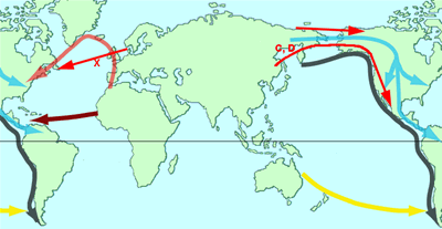
Most contemporary evidence points to a migration of the Native American people from Asia, coming from north-eastern Siberia into Alaska sometime between 25,000 to 11,000 years ago. But there is still much debate about the exact time of this migration and whether it was one migration by a single group of people or different migrations by different groups.

The geological record points to an ice age that occurred from 40,000 to 11,000 years ago. There are two factors that would have influenced this migration. First, tying up so much of the earth’s water into ice would have resulted in a drop in the level of the oceans.

About 60 miles of water presently separate Alaska and Siberia, but in the last ice age, the ocean would have been low enough for these two landmasses to be connected, permitting easy migration from Asia into North America.

Studies of the fossil record indicate that this type of migration has occurred among the great herding animals. Caribou, mammoths, elk, and moose apparently traveled from Asia to North America, and horses and camels migrated the opposite way.

Secondly, the scarring of rock strata indicate that the ice sheet covering North America in this time period was vast, stretching south to the Canadian Pacific coast and across to the Atlantic Ocean. While migration from Asia into Alaska was feasible as early as 25,000 years ago, the ice sheet would have blocked further overland travel into the interior of North America until 14,000 years ago.

Some scientists argue that travel would have been possible along the Alaskan and Canadian coastline, but no evidence has been found as yet to indicate boats or a fishing-based culture in this region prior to 11,000 years ago.

Anthropologists have applied modern language theory and biological techniques to the question of migration. There are more than 1,000 Native American languages, and the North American languages are commonly recognized as falling into eight large, related groups.

Anthropologists have attempted to determine migration patterns tribes based on the dispersion of these language groups. Most agree that three or more migrations occurred, with the first beginning more than 11,000 years ago. The largest language group, the Amerind, links many languages in all regions of North America and is believed to be the earliest.

This migration was then followed later by the Na-Dene group, which is found in the U.S. Southwest and Northwest Coast (some 9,000 years ago), and still later by the Inuit and Aleut speakers of the Arctic (less than 8,000 years ago). Studies of dental traits and blood-group traits among Native Americans also tend to support the concept of three large migration events.

Once Native Americans did become established in central North America, they began to spread out to every region of the continent, and cultures and lifestyles began to evolve and adapt to the various regions. Scientists refer to these earliest cultures as Paleo-Indians. One artifact common to these people is a distinctive flint spear point referred to as the Clovis point.

A number of archaeological sites along the Great Plains have been dated to 11,000 years old, and they show evidence for the use of the Clovis point for hunting the great herds of mammoth, bison, and other animals. Other studies indicate that use of the Clovis point spread throughout North and South America as far north as the Yukon and as far south as the Andes.

Gradually, the climate warmed in North America. The huge herd animals of the ice age, such as the mammoths and mastodons, died out, the vast lakes in the U.S. West dried out and turned to desert, and deciduous forests became widespread in the East.

Native Americans adapted to their new environments and established new ways of life different from their Paleo-Indian ancestors. This second wave of cultures is referred to as the Archaic Tradition.

Archaic-period cultures developed more specific, regionalized characteristics. People of the western deserts utilized the lowland seasonal marshes and rivers for their sustenance or became hunter-gatherers in the foothills and mountains. People of the Northwest developed into great ocean and river fishers.

California Archaic people developed hunting-foraging cultures utilizing the abundance of resources in their region and practiced controlled burning to encourage plant and animal populations, particularly for oaks and acorns. The people of the Great Plains developed a greater reliance on the bison.

Eastern groups began to adapt to the growing woodlands. One particular cultural group is referred to as the Poverty Point culture. This group was first studied based on the Poverty Point earthworks in Louisiana, dated between 4,000 and 2,000 years old.

Poverty Point includes several earthen mound constructions, with the largest taking the form of a bird with outstretched wings. Artifacts uncovered at Poverty Point reveal trade materials originating as far away as the Great Lakes. Clay figurines, stone beads, and other ornaments are distinctive to the Poverty Point culture.

The Woodland culture was the next stage to develop. This term as used by archaeologists refers to a specific Native American cultural pattern that became common about 3,000 years ago and spread from the edge of the Great Plains to the Atlantic Ocean.

The Woodland culture had three main characteristics: a distinctive style of ceramics, community-based agriculture, and the construction of burial mounds. Mound building is perhaps the most recognized Woodland culture feature. Mound structures from this stage have been discovered from the Great Lakes to the Gulf of Mexico and from the southern Great Plains to Ontario.

The Woodland groups again were not a single vast tribe or nation but instead were distinct communities that centered on local village or city sites often with mound structures. The mounds were usually burial structures but also frequently served ceremonial and political purposes.

The Woodland culture showed local variations, but certain practices were common to all. Trade was extensive throughout the network of mound communities, and a certain commonality of cultural practices likely served to unite these communities and help maintain the trade routes.

Elements of both the Archaic and Woodland stages existed in Native cultures up to 1600 c.e. For example, the Archaic fishing cultures of the Northwest and the hunter-gatherer-fishers of California inhabited some of the richest regions on the face of the earth.

Their life-styles never experienced any pressure to change their cultural practices. The early Spanish explorers reported city-states of the Woodland mound culture in the 1500s. The Iroquois tribes in New York are also organized on Woodland culture patterns.

The size of the Native population prior to 1492 is also subject to much debate. Scientific studies in the early 1900s relied on the reports and estimates of the European explorers and American settlers from the 1500s forward. These studies generally agreed on a figure of about 1 million Native Americans north of Mexico at the time of European contact.

More recent studies have begun to take into account additional factors, particularly the effect of Old World diseases. Diseases such as smallpox, chicken pox, the plague, and measles did not exist in the Native American population prior to 1492.

The disastrous effect of these diseases in Mesoamerican and Central and South American Native populations was well documented by the Spanish conquistadores in the 1500s. Given the existence of the extensive Native trade routes and the virulence of these diseases, it is reasonable to assume that these diseases had a similar devastating effect in interior North America as well.

More recent population studies, taking into account the effects of disease and the estimated carrying capacity of the various regions of the continent, have revised the Native American population estimate upward. Some studies have ranged as high as 18 million, but most recent estimates project Native population in North America prior to 1492 as closer to 5 million people.

The indigenous people of North America, their governments, and cultures were incredibly varied, with great adaptation to their respective regions, and they showed a great awareness of and respect for their physical environment.

Native American cultures were not static and had been undergoing cultural changes independent of and prior to European contact. But by 1600 a radical transformation had begun resulting from Old World immigration. At that point disease had begun to decimate Native populations, and this would be one of the key factors in opening the Atlantic seaboard to English colonization in the 1600s.

14 Ocak 2012 Cumartesi

Teotihuacán

Teotihuacán

Teotihuacán
Teotihuacán

Located some 25 miles northeast of Mexico City in the Basin of Mexico, the massive ruins of the great city of Teotihuacán have long puzzled and intrigued observers. Despite more than a century of archaeological investigation, many mysteries remain about the people who built, ruled, and lived in this vast urban complex. The city was founded in the first century b.c.e., just northeast of Lake Texcoco, which lay at the basin’s center.

Its builders were most likely the former inhabitants of the ancient ceremonial center of Cuicuilco, at Lake Texcoco’s southwest corner, which was destroyed in the eruption of the volcano Xitle around 50 b.c.e. Construction on Teotihuacán began soon after the abandonment of Cuicuilco. The city flourished for the next 600 years, dominating most of the central highlands, before its partial destruction and abandonment around 650 c.e.

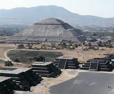
The city’s civic and ceremonial core was built in stages, from its beginnings in the first century b.c.e. to its completion by 300 c.e. Carefully designed in a grid-like pattern, the core was dominated by several towering structures connected by a broad avenue: the massive Pyramid of the Sun; the slightly less imposing Pyramid of the Moon; the Temple of Quetzalcoatl (Plumed, or Feathered, Serpent); and the large open-air Citadel. Scholars offer varying interpretations of its builders’ intentions regarding its orientation, with the Avenue of the Dead at 15.5 degrees west of south.


Some argue that it is aligned with solar equinoxes; others, with the constellation Pleiades; others, with the nearby Cerro Gordo volcano; still others have proposed mathematical relationships between the city’s orientation and the sacred 260-day calendar. All agree that its exacting alignment carried deep meaning for its designers and builders.

Its largest and oldest vertical structure, the massive Pyramid of the Sun, was built over a series of caves (discovered in 1971) whose interior chambers were modified and used extensively during the pyramid’s construction phase (1–150 c.e.).

In Mesoamerican mythology caves were linked to the underworld, the dwelling place of the gods, and the origin of creation, suggesting that the pyramid’s location held profound cosmological significance to its designers.

Estimates of the city’s population range from a low of 80,000, to a high of 200,000. During its first century its population grew rapidly, reaching perhaps 80,000 by 150 c.e., with many thousands of people from the Basin of Mexico migrating to the city.

Growth slowed in subsequent decades, with the city’s population reaching its height probably around 200 c.e. In the 200s and 300s a series of more than 2,000 apartment or residential compounds were built to house the city’s huge population.

The sizes and qualities of these compounds varied considerably, suggesting an intricate system of socioeconomic stratification based on wealth, occupation, status, and lineage. Most scholars agree that persons claiming a common lineage inhabited these compounds.

Different districts or neighborhoods within the city also varied widely. In some areas, specialized craft or artisan workshops predominated. Elsewhere, distinct ethnic enclaves are evident, most notably, a cluster of some dozen compounds evidently inhabited by Oaxacans from Monte Albán.

A "merchant’s neighborhood" has been identified near the city’s eastern perimeter. Throughout much of the city, however, it is difficult to identify specific qualities that defined its spatial demographics. While the remnants of walls can be found in various parts of the city, there is no evidence that the city as a whole was walled. An estimated two-thirds of the city’s inhabitants worked in agriculture, in the fields surrounding city, with the remainder engaged in various types of craft production.

The inhabitants of Teotihuacán employed a system of notational signs but had no system of writing comparable to the Maya during this same period. Scholars have identified no grammatical or phonetic elements in the notational system and thus do not know what languages its inhabitants spoke or what they called themselves.

Some scholars have proposed that its rulers sought to create a secretive, mysterious symbolism; others suggest that the signs’ meanings were probably clear to their creators and those who viewed them. The artistic style at Teotihuacán is repetitive, uniform, and somewhat stiff, in sharp contrast to the great variability of styles and motifs among the Maya city-states.

Religion was practiced in at least two distinct spheres: at the level of the household and village and at the level of the state. Village- and household-level religious practices focused on ancestors and deities linked to specific lineages. There is no evidence that these household- and village-level religious practices were in conflict with the state or that there was any organized or lower-class resistance to the state or ruling groups.

State religion was very distinct from village-level religion, emphasizing especially the cult of the Feathered Serpent, most graphically expressed in the Temple of Quetzalcoatl, with its hundreds of huge sculpted heads gracing its massive walls and stairs.

Other major state deities included what is commonly called Tlaloc, the rain god (though interpretations differ on whether this was indeed Tlaloc), the storm/war god, various death and underworld gods, and what E. Pasztory has termed the Great Goddess.

State religion focused on legitimizing the dominance of ruling groups and providing ideological underpinning for the state and its political, military, and ideological dominion within the Basin of Mexico and beyond. This was a highly stratified and militarized society with both extensive and intensive military capacities.

The city dominated the Basin of Mexico, though probably not much beyond it, and regardless of the extent of its direct rule, it carried enormous ideological prestige throughout Mesoamerica.

Perhaps providing a template for the later Aztec military, Teotihuacán’s armies were divided into military orders associated with particular creatures, such as the eagle and jaguar. Its military forces consisted of both commoners and elites that fought in disciplined groups and were highly effective in their use of dart- and spear-throwers (atlatl) and obsidianstudded clubs.

The city’s impressive military capacities and ideological prestige worked together to facilitate exchange and trade relations with neighboring polities. Trade routes, as far south as Central America and as far north as the present-day U.S. Southwest, linked the city to all of Mesoamerica’s significant polities.

Long-distance trade was especially active in prestige items, such as shells, ceramics, obsidian, mica, hematite, jade, turquoise, and cinnabar. Marketplaces within the city were especially important, some suggesting that the Great Compound was also the city’s central marketplace, with cacao serving as a form of currency.

Ritual human sacrifice was practiced at Teotihuacán, though the practice is depicted in the city’s artwork principally through portrayals of human hearts, some impaled on knives. Skeletons of sacrificial victims have been unearthed in the Pyramid of the Sun, the Temple of Quetzalcoatl, and other buildings.

The decline of the great city was rooted in longterm ecological crises, particularly water shortages, deforestation, and soil degradation, trends exacerbated by a series of invasions or attacks by nomadic or seminomadic peoples from the north. Between 500 and 600 these deleterious ecological processes had become irreversible.

Around 650 much of the city was destroyed by fire, probably by external assailants, and most of its buildings and compounds were abandoned. The core ceremonial area around the temples saw the greatest destruction, suggesting a conscious effort to incapacitate the city’s ritual and ideological power. By 750 the city was completely abandoned.

Some six centuries later, upon their arrival into the Basin of Mexico from the northern deserts, the Aztec would look upon the ruins of Teotihuacán as the dwelling place of the gods. Today Teotihuacán remains one of Mexico’s most popular tourist attractions.