British History etiketine sahip kayıtlar gösteriliyor. Tüm kayıtları göster

1 Eylül 2020 Salı

Networks and Connections in Legal History

Networks and Connections in Legal History

Just out from Cambridge University Press: Networks and Connections in Legal History, edited by Michael Lobban, London School of Economics and Political Science, and Ian Williams, University College London:
Network and Connections in Legal History examines networks of lawyers, legislators and litigators, and how they shaped legal development in Britain and the world. It explores how particular networks of lawyers - from Scotland to East Florida and India - shaped the culture of the forums in which they operated, and how personal connections could be crucial in pressuring the legislature to institute reform - as with twentieth century feminist campaigns. It explores the transmission of legal ideas; what happened to those ideas was not predetermined, but when new connections were made, they could assume a new life. In some cases, new thinkers made intellectual connections not previously conceived, in others it was the new purposes to which ideas and practices were applied which made them adapt. This book shows how networks and connections between people and places have shaped the way that legal ideas and practices are transmitted across time and space.
TOC after the jump. [DRE]
1. Introduction Michael Lobban and Ian Williams
2. Networks and Influences: Contextualising Personnel and Procedures in the Court of Chivalry. Anthony Musson
3. Men of law and legal networks in Aberdeen, principally in 1600-1650.  Adelyn Wilson
4. Calling Time at the Bar: First women barristers and their networks and connections. Judith Bourne
5. The Thistle, the Rose, and the Palm: Scottish and English Judges in British East Florida.  M. C. Mirow
6. 'The Bengal Boiler': Legal Networks in Colonial Calcutta.  Raymond Cocks
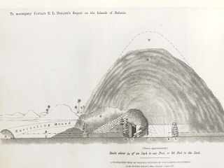
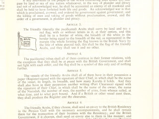
7. The White Ensign on Land: The Royal Navy and Legal Authority in Early Sierra Leone. Tim Soriano
8. A Broker's Advice: Credit Networks and Mortgage Risk in the Eighteenth-century Empire.  Julia Rudolph
9. Trans-Atlantic connections: The many networks and the enduring legacy of J.P. Benjamin. Catharine MacMillan
10. Interpretatio ex aequo et bono – the emergence of equitable interpretation in European legal scholarship.  Lorenzo Maniscalco
11. Shakespeare and the European Ius Commune.  R. H. Helmholz
12. Law Reporting and Law Making: the Missing Link in Nineteenth-century Tax Law.  Chantal Stebbings
13. John Taylor Coleridge and English Criminal Law. Philip Handler

31 Ağustos 2015 Pazartesi

A History of Archaeology in Bahrain

A History of Archaeology in Bahrain

It was a cool winter morning in 1878 when a young British officer by the name of Edward Law Durand (5 June 1845 - 1 July 1920) swept ashore onto the island of Muharraq in Bahrain. Sent by the British Political Residency to conduct an archaeological survey (funded by the British Museum) of the island, his report of the burial mounds was the first archaeological study conducted in the country and in the Gulf since the time of Alexander (or Rome even).

Sketch of a mound from Durand's report (via Qatar Digital Library)
It was on this occasion that he thus became the first European writer to comment on the Bronze Age burial-mounds there, and had the fortune to discover a cuneiform inscription (named the Durand Stone) which he brought back to his family home in Scotland but which was later moved to London where it is believed to have been destroyed during the Blitz.

Durand's Stone is important as it contained Old Babylonian inscriptions. Only when translated by Sir Henry Rawlinson (the forefront scholar in Mesopotamian affairs) did its content become known; it spoke of a devout servant of Dilmun divinity. This quintessentially cemented the Dilmun-Bahrain hypothesis, wherein it is believed Bahrain is the location of the fabled land of Dilmun.


First, a biography of the man;
One of three sons of Sir Henry Marion Durand (1812-1871), who had served with distinction in the First Afghan War and the Indian Mutiny. Educated at Bath, Repton and Guildford; entered the 96th Regiment of Foot in 1865 but transferred to the Indian Political Service in 1868 and in 1870 was selected as ADC and Private Secretary to the Lieutenant-Governor of the Punjab. From 1871-77 he filled various posts in Rajputana and Central India, before briefly serving as Acting Political Agent in Manipur in 1877. In the following year (1878) he was appointed Acting Assistant Resident in Bushire [during which he was sent to Bahrain]. In 1881 Durand was placed in charge of the former Amir of Kabul and from 1884-86 he was Assistant Commissioner for the Afghan Boundary Commission. In 1888 he was appointed Resident in Nepal , where he served from 1889 until his retirement in 1893. He was author of 'Cyrus the Great King' (verse; London 1906), and 'Rifle, Rod, and Spear in the East' (London 1911). He died in London.
                                                                                               - The British Museum

Durand's report on the island (completed in 1879) was forwarded by Ross to A.C. Lyall, then Secretary of the Government of India's Foreign Department, and was later published in 1880 in the 'Journal of the Royal Asiatic Society' (New Series) vol. XII (Part II), pp. 189-227, where it was entitled "Extracts from Report on the Islands and Antiquities of Bahrain" (reproduced with an introduction by Michael Rice in 'Dilmun Discovered: the early years of archaeology in Bahrain', London/New York: Longman 1984, pp. 9-36).

Durand, being a fervent watercolour enthusiast, was said to have painted hundreds of watercolours of Bahrain. Unfortunately, they have been lost to history (although his watercolours from his time in India and Afghanistan exist)

Fortunately, the lovely people at the Qatar Digital Library digitised and uploaded Durand's report, so you may browse it at your leisure. I recommend you go through it, it contains rather vivid descriptions of an island long gone. I'll conclude with Durand's eloquent description of dawn after a particularly sleepless night.


References:

10 Ağustos 2015 Pazartesi

The Gazetteer of the Persian Gulf, Oman and Central Arabia

The Gazetteer of the Persian Gulf, Oman and Central Arabia


The Gazetteer of the Persian Gulf, Oman and Central Arabia (nicknamed Lorimer) [2] is a two-volume encyclopedia compiled by John Gordon Lorimer. Published in secrecy by the British Raj government in 1908 and 1915, it served as a handbook for British diplomats in the Arabian Peninsula and Persia.[1]    

Declassified in 1955 under the fifty-year rule, it was widely praised for its extensive details of the region's history and geography.[2] It is considered to be "the most important single source of historical material on the Gulf States and Saudi Arabia" from the 17th to early 20th century.

History:

At the turn of the 20th century, the British empire sought to solidify its links to British-controlled India which in turn resulted in a greater interest in the Persian Gulf region, culminating in the visit of the Viceroy of India Lord Curzon to the Gulf in 1903. [1] To ensure that British agents in the region were adequately informed and prepared to strengthen their influence in the region, a convenient and portable handbook was needed. [3] 

The British Raj commissioned John Gordon Lorimer, a member of the Indian Civil Service serving in the North-West Frontier Province, to compile such a document in November 1903. Initially given six months to complete the task, Lorimer repeatedly insisted on being granted more time to ensure the work was completed thoroughly. Placed under special duty and with a team of researchers, over the next 10 years, data was collated from government archives in Calcutta and Bombay, and from multiple field expeditions to the Gulf.

The Gazatteer itself:

The gazetteer is a 5000 page document divided into two volumes; the first details the region's history and the second details its geography.[1] The geography portion of the gazetteer was completed first and was published in 1908. The history portion of the gazetteer was only completed and published in 1915, a year after Lorimer himself died in a shooting accident. 

History:

Entitled 'History, geography and geneaology', the volume was split off into three sections which were divided by ethnicity. Section 1 (the Arab section) was dedicated to the history of the Persian Gulf, central Arabia and Ottoman Iraq. Section 2 (the Persian section) regarded the history of Persia with particular interest to the predominately-Arab populated region of Arabistan. Section 3 consisted of 19 genealogical trees of the ruling families in the region. [4] 

Its research was compiled from Lorimer's own notes and colleagues such as J.A. Saldanha and C.H. Gabriel and covered various periods ranging the 17th to 20th centuries. [1] 

Geography:

Entitled the 'Geographical and Statistical' section, it is a 2000 page document and lists an extensive alphabetical arrangement of tribes, towns and villages across the region, divided into different countries.[4] 

This data was obtained through field trips and surveys conducted by Lorimer and his team.[1] Also in the volume are 56 reproduced images of the region taken from colonial records and two maps showing the distribution of pearling sites and the overall political geography.

Legacy:
Map of the Persian Gulf, Oman and Central Arabia, compiled by Hunter  (IOR/L/PS/20/C91/6, f. 1r)
 Classified for official use only, it was published in secrecy in 1908 and 1915 respectively with only dozens of copies in circulation. As such, there was no public awareness of the existence of such a document. Consequently, Lorimer's obituary makes no mention of his extensive encyclopedia.[2] Only when declassified in 1955 was he officially credited. [5]  

In 1971, The Times Literary Supplement praised the document, regarding its historical coverage as "stupendous" and its geographical section as "without modern substitute". The gazetteer, relying on British sources and written from a British viewpoint, is regarded as a valuable resource in researching the history of the Gulf. [1]  

The gazetteer in its entirety was digitised and uploaded online by the Qatar Digital Library in January 2015.[5]

Further reading and references:


Lowe, Daniel A. "‘Persian Gulf Tragedy’: the Death and Legacy of John Gordon Lorimer". Qatar Digital Library. Retrieved 10 August 2015. 

Leech, Nick (7 January 2012). "A reference book for every historian to rely on". The National. 

Lowe, Daniel. "Colonial Knowledge: Lorimer’s Gazetteer of the Persian Gulf, Oman and Central Arabia". Qatar Digital Library. Retrieved 10 August 2015.

 Lowe, Daniel (6 December 2014). "The diplomat’s portable handbook (wheelbarrow required)". BBC News. Retrieved 10 August 2015. 

Author's note: the above was previously posted onto Wikipedia first. 

17 Temmuz 2015 Cuma

"Your Spitfires At Work!" British Propaganda Poster in the Persian Gulf

"Your Spitfires At Work!" British Propaganda Poster in the Persian Gulf

© IWM (Art.IWM ART LD 5268)
The nature of propaganda is intertwined with that of human nature. Propaganda served as a way to solidify public support, decimate the reputation of the enemy, further one's ego and reputation (indeed, one of the earliest pieces of propaganda are those detailing the rise of Darius of Persia). In times of war, the home front is as crucial as the battlefront and propaganda is always an effective tool in a government's arsenal. In this post, I'm sharing this poster made by the British (likely the British Civilian Organisation) destined towards the British protectorates of the Persian Gulf whom had donated funds to the war cause (indeed, the hakim of Bahrain donated £30,000)

The title reads "Your [Persian Gulf] Spitfires in Action". Official transcript of the poster lies below:

[top left] One of the four fighter aircraft donated by the people of the Persian Gulf. The other three aircraft are called 'Bahrain', 'Kuwait' and 'Oman'.

[top right] When enemy bombers come close to Britain, fighter aircraft go to chase them and drive them away. The picture shows one of your fighter aircraft shooting down an enemy bomber.

[bottom left] Your fighter aircraft participate in sweeping raids on enemy territory, and their machine guns inflict huge losses on enemy ships, transport and communication routes.

[bottom right] Your fighter aircraft protect the Allies’ commercial ships against the attack of enemy aircraft. Good surveillance and vigilance of the fighter aircraft only played a major role in the arrival of many military shipments into their destination ports.

[bottom text] Countries of the Persian Gulf voluntarily participated in the daily punishment administered by the RAF to the aggressive Nazi State.

This photograph shows the spitfire (entitled Bahrain) that was donated to the Royal Air Force after raising £15,000 to buy it. The plane itself was piloted by Air Vice-Marshal (Flying Officer during the Battle of Britain) Francis David Stephen Scott-Malden.

His entry at ‘The Airmen’s Stories’ section of the Battle of Britain London Monument website reads:
‘Bearing the initials "S-M" below the cockpit and the legend "Bahrain", Scott-Malden's Spitfire W3632 - built at the Supermarine factory at Woolston, Hampshire - was a gift from the people of Bahrain, who had raised £15,000 to buy it.’
In his Bahrain plane, Scott-Malden led one of the Free Norwegian fighter squadrons leading three sorties in one day during the disastrous Deippe raid of August 1942. Scott-Malden was later awarded the Distinguished Service Order and decorated by the King of Norway.

 If you are interested, you can read about the role of Bahrain during the Second World War

27 Haziran 2015 Cumartesi

The Treaty that Outlawed Slavery in the Gulf

The Treaty that Outlawed Slavery in the Gulf

Officially known as the General Treaty for the Cessation of Plunder and Piracy by Land and Sea, this treaty was initially signed between the British government (represented by the British India government) and  the rulers of Abu Dhabi, Sharjah, Ajman and Umm al-Quwain on the 11th of January 1820. Bahrain later signed the treaty in February. This treaty is significant due to the simple fact it effectively outlawed piracy and slavery in the Gulf, whilst also requiring seaworthy ships to be registered with the British.

This was part of a greater strategy employed by the British to exclude European powers (especially the ever-threatening Russian Empire) from exerting influence in the Middle East and disrupting communication lines with British-controlled India.

Thanks to the wonderful people at the Qatar Digital Library who have digitised more than 500,000 scans & documents from the archives of the India Office records and many more; we are able to see a transcript of the actual document signed below. Wikisource also has a transcribed copy.

Page 1, from the Qatar Digital Library

Page 2, from the Qatar Digital Library
  • A Collection of Treaties and Engagements relating to the Persian Gulf Shaikhdoms and the Sultanate of Muscat and Oman in force up to the End of 1953' [‎19v] (40/92), British Library: India Office Records and Private Papers, IOR/R/15/1/738, in Qatar Digital Library <http://www.qdl.qa/en/archive/81055/vdc_100023550810.0x000029> [accessed 27 June 2015]

2 Ağustos 2013 Cuma

Freshen Up With Archaeology Friday (Post X)

Freshen Up With Archaeology Friday (Post X)

Coffin within a coffin found near Richard III site

Archaeologists have unearthed a mysterious coffin-within-a-coffin near the final resting place of Richard III

The coffin-in-a-coffin. (Photo from the University of Leicester)
The University of Leicester team lifted the lid of a medieval stone coffin this week -- the final week of their second dig at the Grey Friars site, where the medieval king was discovered in September.
This is the first fully intact stone coffin to be discovered in Leicester in controlled excavations -- and is believed to contain one of the friary's founders or a medieval monk.

Within the stone coffin, they found an inner lead coffin -- and will need to carry out further analysis before they can open the second box.

Archaeologists have taken the inner lead coffin to the University's School of Archaeology and Ancient History, and will carry out tests to find the safest way of opening it without damaging the remains within.

It took eight people to carefully remove the stone lid from the outer coffin -- which is 2.12 metres long, 0.6 metres wide at the "head" end, 0.3 metres wide at the "foot" end and 0.3 metres deep.
The inner coffin is likely to contain a high-status burial -- though we don't currently know who it contains.

Full article

Oldest European fort in inland America discovered in the Appalachian mountains:
The uncovered fort (Photo from the University of Michigan)
The remains of the earliest European fort in the interior of what is now the United States have been discovered by a team of archaeologists, providing new insight into the start of the U.S. colonial era and the all-too-human reasons spoiling Spanish dreams of gold and glory. 

Spanish Captain Juan Pardo and his men built Fort San Juan in the foothills of the Appalachian Mountains in 1567, nearly 20 years before Sir Walter Raleigh's "lost colony" at Roanoke and 40 years before the Jamestown settlement established England's presence in the region. 
"Fort San Juan and six others that together stretched from coastal South Carolina into eastern Tennessee were occupied for less than 18 months before the Native Americans destroyed them, killing all but one of the Spanish soldiers who manned the garrisons," said University of Michigan archaeologist Robin Beck.  Beck, an assistant professor in the U-M Department of Anthropology and assistant curator at the U-M Museum of Anthropology, is working with archaeologists Christopher Rodning of Tulane University and David Moore of Warren Wilson College to excavate the site near the city of Morganton in western North Carolina, nearly 300 miles from the Atlantic Coast. 

 The Berry site, named in honor of the stewardship of landowners James and the late Pat Berry, is located along a tributary of the Catawba River and was the location of the Native American town of Joara, part of the mound-building Mississippian culture that flourished in the southeastern U.S. between 800 and about 1500 CE.

In 2004, with support from the National Geographic Society and the National Science Foundation, Beck and his colleagues began excavating several of the houses occupied by Spanish soldiers at Joara, where Pardo built Fort San Juan. Pardo named this small colony of Spanish houses Cuenca, after his own hometown in Spain. Yet the remains of the fort itself eluded discovery until last month. 
"We have known for more than a decade where the Spanish soldiers were living," Rodning said. "This summer we were trying to learn more about the Mississippian mound at Berry, one that was built by the people of Joara, and instead we discovered part of the fort. For all of us, it was an incredible moment."  
Using a combination of large-scale excavations and geophysical techniques like magnetometry, which provides x-ray-like images of what lies below the surface, the archaeologists have now been able to identify sections of the fort's defensive moat or ditch, a likely corner bastion and a graveled surface that formed an entryway to the garrison.

Excavations in the moat conducted in late June reveal it to have been a large V-shaped feature measuring 5.5 feet deep and 15 feet across. Spanish artifacts recovered this summer include iron nails and tacks, Spanish majolica pottery, and an iron clothing hook of the sort used for fastening doublets and attaching sword scabbards to belts. 

Fort San Juan was the first and largest of the garrisons that Pardo founded as part of an ambitious effort to colonize the American South. Pedro Menéndez de Avilés, who had established the Spanish colonies of St. Augustine and Santa Elena in 1565 and 1566, respectively, spearheaded this effort. Of the six garrisons that Pardo built, Fort San Juan is the only one to have been discovered by archaeologists.


Today's featured reading:

27 Haziran 2013 Perşembe

My visit to Canterbury, London and beyond

My visit to Canterbury, London and beyond

Frequent readers may note that the blog has been quiet as of late this month but don't worry, I have a perfectly valid excuse, at least from my point of view. This month, I had a hectic visit to the UK to visit some relatives and generally do a bit of sightseeing. I've been to the charming Cathedral-and-University-town of Canterbury in England's garden region of Kent for around 10 days, after which I took the train to incredibly-complicated and ever-so-noisy London (I admit, I favoured Canterbury better) where, as you can imagine, I loitered immensely at the museums there.

I don't usually do personal posts but I suppose it's been too long since the last one. Instead of presenting a wall of text, I'll post photos of the stages of my trips, from Bahrain Airport's departure till Heathrow's, and I'll try to keep it short (I took 400 photographs, incredibly).

Bahrain Airport and Departure:
I got the window seat and being the over-excited person I am, I snapped photos out the window. In my defence, it was a six-hour flight.

Morning flights are the worst.

Basra's river networks.


This is probably Basra. Probably.

We approached the mountains of Kurdistan


This is somewhere over Central Anatolia but I forgot its name.


Shadows of clouds!

Its shadow reminded me of Asia, somehow.

Still in Turkey, it's amazing how clouds look like from above.


The Romanian coastline, from the Black Sea. First time I see Europe.

Another view of the coast. Romania is green....

...and just as cloudy as Turkey.

Hungary and Austria were super-cloudy, I assumed it was flooding.

Spotted this monster cloud just south of Dresden (6 June)

I see German land for the first time!

Approaching the Netherlands

Final piece of continental Europe, Dutch land reclamation fully visible.
Train ride!
This was the first time I ever used a train so naturally, I was overly excited. The train moved so fast and at times, I thought we'd hit the train on the other side of the tracks! Note to self, never sit by the window ever again.


I think I now realise why Kent is called England's garden.

Canterbury:

Canterbury is a small city located in southeast England and a popular tourist destination amongst the British (and generally anyone who likes really old buildings). The pride of the city is the majestically built Canterbury Cathedral that was first founded in 597 AD, which also hosts the leader of the Anglican Church, the Archbishop of Canterbury. Aside from that, the hub of the city is the seemingly never-ending multitude of ancient buildings lining up High Street, forming Canterbury's city centre. One observation I've made is that, as a person coming from a country were public transportation is neglected, the amazing efficiency of the bus system in the city came as a surprise. It was well maintained and reasonably cheap, I only wished this was the case in Bahrain.
Old Blighty lives up to its name.

Old and new Canterbury; the city walls - now a walkway!

Canterbury castle's walls were walking paths! How awesome is that?
A mound dating back to Roman times.

Found this close by (stupid graffiti)
One of the many ruined towers along the walls.

It goes on for a while.

To your left; trees growing in the adjacent park (I've never seen so much greenery)
To your right, asphalt.

These flowers were everywhere. Can someone identify them?

This was in the park, it looked stunning.

Amazing view.

I found so many pennies in the fountain

Canterbury's city centre! So busy and bustling with tourists.

And the first museum I visit; nicknamed The Beaney.

2:30pm 27/6/2013 - Well that is enough photos for now at least, due to time constraints I'll post more photos of my trip at a later time (making this one really long photo-post). Thank you for your patience and be sure to leave your thoughts in the comment section. 
 x___________x______________x________________x_____________x______________x

10th of July, 2013 - Well that was a rather long break. To compensate, here are some photos from the Beaney.

From what I gathered, the Royal Museum & Free Library (cutely called The Beaney) is dedicated primarily to a Canterbury-born Dr. James Beaney, a Victorian surgeon in the British army who served in the Crimean War and later became a politician in Australia. In the building, there was also a permanent art gallery showcasing the works of the renown English landscape artist, Thomas Sidney Cooper, who had a thing for cattle.

A friend told me the place was basically the treasure house of a Victorian adventurer... he wasn't joking.

A donation from the public in the Cooper exhibit.

One of his works (apologies for the horrible quality)

It has to be said that this looks more impressive in person.

Upstairs in the building lies Oriental "loots", such as this camel skull.

And the obligatory ancient-Egyptian cat statues.

Medals belonging to Dr. Beaney (he was a busy man)

A letter written in blood, showcased on the top floor.

Trophies amongst others.

More loot from the Orient.

This was in the animal exhibit. A stuffed falcon, I believe.

More stuffed birds.

A fox... (Look away, bunny)

Stuffed red squirrels

Materials were also on display.

I've always wanted to see a badger...

Taj Mahal painting in the museum.

And amazing china.

If only I remembered to look at the labels.
A bust of Dr. Beaney, I presume?

These paintings were beautiful. More so in person.

Literally a letter in a bottle. Try to read it.

This is a seed! (Allegedly)

More medals for Dr. Beaney, I suppose.

One thing has to be stressed, the stained windows were gorgeous.
 This concludes this update. Next time, I'll be posting photos from the Canterbury Heritage Museum and if time permits, Whitstable! Ciao.