creek nation etiketine sahip kayıtlar gösteriliyor. Tüm kayıtları göster

22 Haziran 2011 Çarşamba

Cheaha State Park - Alabama's Highest Point

Cheaha State Park - Alabama's Highest Point

Cheaha State Park in Alabama
One of my favorite summer destinations in Alabama is the stunningly beautiful Cheaha State Park located atop Alabama's tallest mountain.

The temperature on top of the mountain is always much cooler than it is down below and the scenery is quite simply some of the most beautiful you will find anywhere. With its trails, accessible boardwalk, overlooks, picnic areas, campground, cabins, chalets, hotel and restaurant, Cheaha is a great place to get away from the heat and humidity of summer.

Overlook at Cheaha State Park
The name "cheaha" interprets loosely from the Muskogee or Creek language as "high place." The Talladega Mountains, of which Mount Cheaha is a part, were once the domain of the mighty Creek Confederacy. "High place" is a logical name for the mountain, which dominates the horizon as you approach via the beautiful Cheaha Scenic Highway.

Defeated Creek warriors fled into these mountains after Andrew Jackson defeated them in the Battle of Talladega in 1813. The country was so rugged and rough that the Tennessee soldiers of Jackson's army did not attempt to pursue the retreating Indians into the hills.

Talladega National Forest
After the Upper Creeks were forced to what is now Oklahoma on the Trail of Tears in 1836-1837, these lands were opened to white settlement. The trees that covered the mountains were harvested and in quite a few places gold mining even took place. By the 20th century, much of the Talladega Mountains country was bare.

Bunker Tower atop the Mountain
That changed during the Great Depression, when President Franklin D. Roosevelt's Works Progress Administration (W.P.A.) teamed up with the State of Alabama to replant the forests of the mountains, create Cheaha State Park and turn the entire area into a beautiful natural setting. Workers from the Civilian Conservation Corps (C.C.C.) labored for years building facilities and planting trees. The result of their work is today's beautiful state park and the surrounding Talladega National Forest.

Cheaha State Park is located near the cities of Talladega and Anniston about one-hour east of Birmingham and about 90 minutes west of Atlanta. To learn more, please follow these links:

21 Haziran 2010 Pazartesi

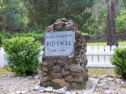
William Weatherford's Grave - Baldwin County, Alabama

William Weatherford's Grave - Baldwin County, Alabama

A stone cairn in Baldwin County marks the burial place of one of the most noted Indian leaders in American history - William Weatherford.

The son of a white trader and a Creek woman who was a sister of the famed Creek leader Alexander McGillivray, Weatherford was born in Alabama during the 1700s. William's father was not as a breeder of outstanding horses and the family's wealth increased dramatically under the younger Weatherford's guidance during the early 1800s. White settlers flooded to the Tensaw country (north of Mobile), creating markets for horses and other products from Weatherford's plantations.

A friend of the whites for much of his life, William Weatherford assisted in the capture of famed renegade William Augustus Bowles in 1803. In 1813, however, something dramatic happened in his life.

The Creek Prophet Josiah Francis, a disciple of Shawnee Prophet Tenskwatawa, had ignited a religious fervor among many in the Nation. Teaching that the Indians should end all association with the whites and return to their native ways, Francis developed a huge following. His followers were called Red Sticks because the displayed red war clubs in their villages.

There are various stories about how William Weatherford became a Red Stick. Some claim that he joined when his life was threatened. Others tell the story that he became a member of the movement in order to save his family. Benjamin Hawkins, the U.S. Agent to the Creeks, reported in 1813, however, that Weatherford had been captured by the Red Sticks at the Battle of Burnt Corn Creek.

However he joined, Weatherford went on to help lead Red Stick forces at the bloody Fort Mims Massacre in August of 1813 and later fought in other battles against the whites. He surrendered to Andrew Jackson in 1814, but his life was spared and he subsequently fought on the side of the United States against the remaining Red Sticks. When the wars ended, he returned to his plantation on the Alabama River.

To learn more about his grave site in Baldwin County, please visit www.exploresouthernhistory.com/weatherford.

1 Mayıs 2010 Cumartesi

Fort Toulouse - Wetumpka, Alabama

Fort Toulouse - Wetumpka, Alabama


In 1717, a party of French soldiers arrived at the head of the Alabama River near the modern cities of Wetumpka and Montgomery.

Their mission was to establish a permanent presence for the King of France in the deep wilderness of Alabama, then under the control of the Creek Nation. The French had cultivated strong ties with the Alabamas (also spelled Alibamos), who lived around the point where the Coosa and Tallapoosa Rivers joined to form the Alabama. A branch of the Upper Creeks, but possessing their own languages and customs, the Alabamas were actually a conglomeration of several smaller tribes.

The French needed a presence among them to half English expansion into the Creek country, which was then claimed not only by the Creeks and the French, but by the English and Spanish as well. A log fort called Fort Toulouse, named for the Count de Toulouse who was a son of King Louis XIV, was built on the Coosa River side of the point of land formed by the confluence of the Coosa and the Tallapoosa Rivers.

Despite its remote position deep in the wilderness that then covered virtually all of Alabama, the little settlement at Fort Toulouse survived for more than 45 years. The French built homes, cultivated gardens, intermarried with Indian women and engaged in trading and exploring. Although Fort Toulouse was surrounded by stockade walls and armed with small pieces of cannon, it owed its general survival to the goodwill of the Alabama who remained strongly loyal to the French despite the increasing influence of the English among the Creeks.

Over time, the fort was rebuilt at least once as the Coosa River slowly eroded away the bluff on which it stood. Archaeologists have found the remains of one of the corner bastions (angled projections that extended from the corners of the fort to allow infantry and cannon to sweep the walls in the event of an attack) of the original fort as well as buried traces of the second. Their work at the site has allowed modern interpreters to reconstruct Fort Toulouse so that visitors today can see the important early structure as it originally appeared.

Fort Toulouse was evacuated by the French in 1763 due to the treaty that ended the French and Indian War. Their homes and gardens were reclaimed by the forest and the fort itself soon rotted away. By the end of the century, the only remains still to be seen were a few old cannon abandoned at the site.

To learn more about Fort Toulouse and the other historic features of the site, please visit www.exploresouthernhistory.com/forttoulouse.

26 Nisan 2010 Pazartesi

Chattahoochee Indian Heritage Center - Fort Mitchell, Alabama

Chattahoochee Indian Heritage Center - Fort Mitchell, Alabama

Perhaps the most beautiful and emotion-invoking monument in Alabama stands on a high ridge overlooking the Chattahoochee River valley at Fort Mitchell. It memorializes the last ceremonial fire of the Creek Nation before its removal west on the Trail of tears.

A centerpiece of the Chattahoochee Indian Heritage Center, the Ceremonial Flame memorial reminds visitors of the significance of the land on which they are walking. This site, adjacent to the old U.S. Army post of Fort Mitchell, was where thousands of Creek men, women and children were assembled in camps before being moved west under military escort. Untold numbers of them died due to starvation, disease, exposure and other hardships before they reached the Indian Nations of today's Oklahoma.

Panels surrounding the memorial list the names from the final census of the Creeks before their "removal." They provide an startling reminder of how many Creek families once lived in Alabama and how many lost their homes in 1836-1838 when they were driven from their land.

The Heritage Center adjoins Fort Mitchell Historic Site, which features a beautiful visitor center/museum, restored frontier fort and other historic sites and exhibits. The two combine to create one of the most interesting and educational heritage attractions in Alabama.

To learn more, please visit www.exploresouthernhistory.com/ALChatt1.